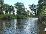
North Platte River
From CO state line to I-80
The North Platte is a big river, covering
lots of territory and diversity in Wyoming. There are quite a few public
access points to the river. One of the best ways to fish the river is by
floating
it. Most access points have boat ramps or places for put-in and take-out.
Be sure to pick up a current Wyoming fishing regulations book, or check
locally for regs.
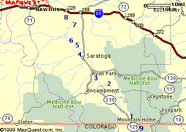
We have listed 9 access points for you
here. All are identified by number on the map
at the bottom of this page.
Information on river reports and stream
flows can be found on our reports page. More
info on the area can be found on the page for
Saratoga -
Platte Valley C of C
Key:
- Fish:
B, R, C, W for Browns, Rainbows,
Cutthroats, Walleye
- Facilities: T, Camp,
Boat for Toilets, Camping, Boat Ramp or access
- Number
(1)
corresponds to location on map
|
Six Mile Gap (1)
- Go east and south from
Riverside on WY 230 for 25 miles. Turn East on USFS road 492
(signed as "6 Mile Rd")
- Fish:
R, B
- Facilities: T, Camp
-
Info on camping - Six Mile Gap campground
|
Bennett Peak (2)
- Go east from Riverside on WY
230 for 4 miles. Sign for BLM Bennett Peak Campground. Turn
north on Cnty Rd 660; go 13 miles and turn north on BLM Rd 3404;
continue 6 miles to N. Platte River
- Fish: B, R
- Facilities: T, Camp, Boat
-
Info on camping
|
Treasure Island (3)
- Go south from
Saratoga on WY 230 for 9 miles. Turn east on dirt road signed by
fish and game
- Fish: B, R
- Facilities: T, Camp, Boat
- More photos
|
Treasure Island access
|
Foote Access (4)
- Go north from Saratoga on WY
130 for 4 miles. Turn west on dirt road (signed by fish and
game); continue 1.5 miles to N. Platte River
- Fish: C, R, B
- Facilities: T, Camp
|
 |
Pick Bridge (5)
- Go north from Saratoga on WY
130 for 7 miles. Turn west on Pick Bridge Road and follow for 3
miles to where bridge crosses the N. Platte
- Fish: B, R
- Facilities: T, Camp
|
Frazier (6 0
- Go north from Saratoga on WY
130 for 7 miles. Turn west on Pick Bridge Road and follow for 4 miles.
- Fish: B, R
- Facilities: T, Camp,
Boat
|
Ft. Steele/Rochelle (7)
- At Ft. Steele exit off I-80, 15 miles east of Rawlins. Follow S. frontage road; access for
portions of 11 miles of river
- Fish: B, R, C, W
- Facilities: T
|
Interstate Bridge (8)
- At the Ft. Steele exit off I-80, 15 miles east of Rawlins; both sides of highway
- Fish: B, R, C, W
- Facilities: Camp, Boat
|
N. Platte - Colorado Side
(9)
- It is popular to float from Colorado, through Northgate Canyon for takeout at Six Mile
-
More info on the Colorado side (which is Gold Medal and Wild Trout water)
|
 EBook on CD in Adobe pdf format. Print the maps or
descriptions you need. Available now, Fly Fisher's Guide to the North Platte
click here
EBook on CD in Adobe pdf format. Print the maps or
descriptions you need. Available now, Fly Fisher's Guide to the North Platte
click here