The Big Horn River is the continuation of
the Wind River, after it flows north to Thermopolis through Wind River
Canyon. The name changes occur at Wedding of the Waters. Be sure to pick
up a current Wyoming fishing regulations book, or check locally for
regs.
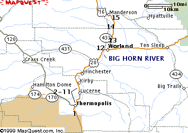
We have listed 18 access points for you
here. These are provided through BLM or WG&F easements. All are
identified by number on the map at the bottom
of this page. This river is accessed nicely by a float trip. Check with
local guide services in Thermopolis.
Key:
- Fish: B, R, C, Cat, W, S for Browns, Rainbows, Cutthroats, Channel Catfish, Walleye, Sauger
- Facilities: T, Camp for Toilets, Camping
- Number (1)corresponds to location on map
|
Wedding of the Waters (1)
- Go south from Thermopolis on US 20 for 4 miles; the Big Horn becomes the Wind River upstream
from Wedding of the Waters; access from road next to river;
special permit needed to fish on Wind River Indian Reservation.
Some access to tailwaters at
Boysen State Park
- Fish: R, C, B
- Facilities: T
|
Thermopolis Bridge (2)
- East of US 20 and Broadway at the river
- Fish: B, C, R
- Facilities:
|
Hot Springs State Park (3)
- Go north from Thermopolis on US 20 to Hot Springs State Park
- Fish: B, C, R
- Facilities: T
- More info at the State Park website
|
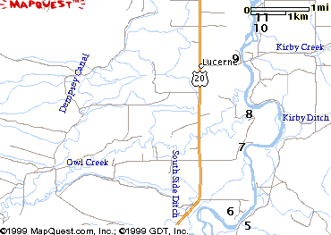
Kirby (4)
- Go north from Thermopolis on US
20 to Hot Springs State Park. Turn east of hot springs access
road for 1/2 mile. Turn north on Cnty Rd 8 and go 2.7 miles to
access
- Fish: B, C, R
- Map from WY Game and Fish
|
McCarthy (5)
- Go north from Thermopolis on US
20 to Hot Springs State Park. Turn east of hot springs access
road for 1/2 mile. Turn north on Cnty Rd 8 and go 3.5 miles to
access
- Fish: B, C, R
- Map from WY Game and Fish
|
Wakely (6)
- Go north from Thermopolis on US 20 for 5 miles; turn east on Shaffer Drive; go 0.6 miles to
Wakley Ranch; turn south and go 0.4 miles to river access
- Fish: B, C, R
- Facilities: T
- Map from WY Game and Fish
|
Sunnyside Road/Shaffer(7)
- Go north from Thermopolis on US 20 for 6 miles; turn east on Sunnyside Rd (Cnty Rd 27); go 1 mile to river access
- Fish: B, C, R
- Facilities: T
|
Sunnyside Road/Longwell (8)
- Go north from Thermopolis on US 20 for 6 miles; turn east on Sunnyside Rd (Cnty Rd 27); go 1.7
miles through Longwell Ranch to river access
- Fish: B, C, R
- Facilities: T
|
Marino (9)
- Go north from Thermopolis on US 20 for 7 miles; turn east on WY 172, Black Mtn Rd; go 0.6 miles;
turn south onto dirt road; travel 0.2 miles to access
- Fish: B, R, C
- Map from WY Game and Fish
|
Black Mtn Rd./Skelton (10)
- Go north from Thermopolis on US 20 for 7 miles; turn east on WY 172, Black Mtn Rd; go 1 mile and
cross Big Horn; go 1 mile; turn north onto Skelton Road (cnty Rd 21); drive 1.1 miles to access
- Fish: B, R, C
|
Black Mtn Rd./Sorenson (11)
- Go north from Thermopolis on US 20 for 7 miles; turn east on WY 172, Black Mtn Rd; go 1 mile and
cross Big Horn; go 1 mile; turn left onto Skelton Road (cnty Rd 21); drive 1.2 miles to access
- Fish: B, R, C
- Map from WY Game and Fish
|
Worland: Riverside Park (12)
- In Worland, east side of river; turn north on 2nd St and west onto Robertson Ave
- Fish: B, Cat, W, S
|
Worland: Walk-In Access (12)
- In Worland, west side of river; off Hwy 20 at and near Fifteenmile Creek confluence. Detailed map by
clicking here
- Fish: B, Cat, W, S
|
Duck Swamp (13)
- Go north from Worland for 2.5 miles on WY433
- Fish: B, Cat, W, S
|
Walk-In Access (13)
- Go north from Worland for 5.5 miles on Hwys 16 and 20. Turn west on Ln 6. Detailed map by
clicking here
- Fish: B, Cat, W, S
|
Rairden Bridge (14)
- Go north from Worland on WY433 for 12.7 miles; turn east on Rairden Ln; travel 1 mile
- Fish: B, Cat, W, S
|
Walk-In Access (15)
- Go south from Manderson on Hwy 433 for 3 miles. Turn north on Ln 31 1/2 to parking areas. Stay
on roads. Detailed map by
clicking here
- Fish: B, Cat, W, S
|
Manderson Bridge (15)
- In Manderson on US20 at bridge
- Fish: B, Cat, W, S
|