|
Cross Creek was glass clear. Rocks on the bottom, two
feet below the surface, appeared to be only inches away. A few feet
upstream, the water's surface was disturbed and a tiny insect became a
trout's dessert. In seconds, the evidence was gone. The stream again
flowed smooth and serene in the Cloud Peak Wilderness.
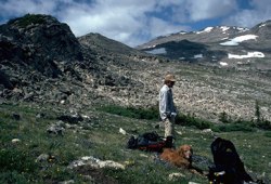 Along
the trail to Highland Park, horseshoe prints had started to fade. Equine
calling cards scattered on the ground were dry. Horses had not been on
the trail since the previous autumn, causing my son Karl and I to
wonder if snow might perhaps block the higher passes. In a few spots,
the trail led down steep grades. Loose rock caused the backpackers to
consider the consequences of a slip. Along
the trail to Highland Park, horseshoe prints had started to fade. Equine
calling cards scattered on the ground were dry. Horses had not been on
the trail since the previous autumn, causing my son Karl and I to
wonder if snow might perhaps block the higher passes. In a few spots,
the trail led down steep grades. Loose rock caused the backpackers to
consider the consequences of a slip.
Named for the highest peak in the Bighorn Mountains,
the Cloud Peak Wilderness Area was established in 1932, and was first
managed as a Primitive Area by the Forest Service. Cloud Peak, 13,175
feet high, is located near the center of the 300 square mile wilderness.
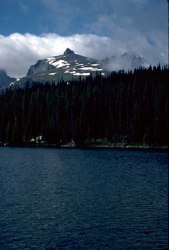
It is drained in all directions by countless creeks and streams. Its
glacially carved hanging valleys are dotted with innumerable clear
alpine lakes. Dense pine forests, boulder fields, and large open parks
predominate in a landscape punctuated with high barren peaks.
Here, the landscape is rugged. It is young,
geologically. Scattered remnants of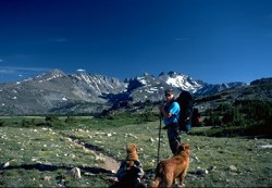 once massive glaciers still cling to the mountains on north- and
east-facing slopes. Along valleys, gouged out by mile-thick ice at the
close of the Pleistocene, moraines, sinuous ribbons of granite boulders,
bear silent witness to where the glaciers finished their work.
once massive glaciers still cling to the mountains on north- and
east-facing slopes. Along valleys, gouged out by mile-thick ice at the
close of the Pleistocene, moraines, sinuous ribbons of granite boulders,
bear silent witness to where the glaciers finished their work.
Timberline is low in the Bighorns, scarcely more than
10,000 feet to perhaps 10,500. Alpine meadows extend for miles in
places. In July of '91, they were covered with countless forms of
wildflowers in blue, red, yellow, white, and all shades in between.
Paintbrush in yellow, red, and a magenta that's almost fluorescent
sprout from the earth in seemingly unlikely places. Alpine
forget-me-nots with brilliant, tiny blue petals cover the high meadows,
causing one to be careful about stepping off a trail. Bright pink alpine
laurel blossoms line the moist banks of high lakes.
The Cloud Peak Wilderness has an extensive network of
trails. With adequate provisions, a traveler could wander for weeks, as
did Bridger, Colter, and others, seeing few if any other humans. It
would be easy to transport oneself back a century and a half to share
the same vistas the Sioux and Cheyenne called home.
The Hunter Corrals trailhead is recommended by the
Forest Service for horse travelers. It has holding pens and loading
ramps for horses and parking for horse trailers and tow vehicles. The
corrals give access to several trails heading into the Cloud Peak
Wilderness. Hunter Corrals is about 12 miles west from the town of
Buffalo and a mile off US 16.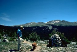
The Solitude Trail heads at the Corrals and is one of
the more popular routes. It makes a loop that takes the wilderness
traveler through the heart of the wilderness in a distance of about 70
miles.
The trail heads west from the Corrals, crossing the
wilderness boundary after about five miles. Two miles further, at
Soldier Park, the trail divides. The fork to the right takes you past
Elk Lake, Frying Pan Lake, just off the main trail, and around Willow
Park Reservoir. From there, you'll follow Kearny Creek on the way to
Highland Park, a square mile of flat, lush, green meadow in an alpine
setting.
After leaving the Park, the trail crosses three easy
passes on the way to the northern boundary of the wilderness. It soon
connects with the East Fork of Big Goose Creek, which leads south to
Lake Geneva and over Geneva Pass. Eventually, you'll arrive at Lake
Solitude, set at the bottom of a steep-walled valley in the shadow of
11,321-foot Elk Mountain. The trail is now heading east toward Florence
Pass, the high point of the ride at 10,800 feet. From the pass, it's all
down hill through a long, nearly flat, outwash plain, where the trail
winds its way in and out of the trees on the way to Soldier Park and the
Corrals.
There are several campgrounds along the trail,
although it isn't required that they be used. In some of the more
heavily used sites, gathering firewood may be a chore as the easy-to-get
wood is gone.
 From
many sections of the trail, Cloud Peak and its nearby neighbor, Black
Tooth Mountain, are visible, serving as prominent landmarks. Several
square miles around Cloud Peak are covered with lakes. Anglers will need
to carry fishing tackle. A nine-foot, four-piece fly rod in weight five
or six will work just fine. A weight forward line will make long casts
on the windy lakes a bit easier. Spin fishermen should take an
assortment of lures like Mepps, Panther Martin, and Rooster Tail
spinners as well as an assortment of spoons. Bait is legal to use on the
many rainbow, brook, and cutthroat trout but the fish are so eager to
hit a lure, worms are almost too much trouble. From
many sections of the trail, Cloud Peak and its nearby neighbor, Black
Tooth Mountain, are visible, serving as prominent landmarks. Several
square miles around Cloud Peak are covered with lakes. Anglers will need
to carry fishing tackle. A nine-foot, four-piece fly rod in weight five
or six will work just fine. A weight forward line will make long casts
on the windy lakes a bit easier. Spin fishermen should take an
assortment of lures like Mepps, Panther Martin, and Rooster Tail
spinners as well as an assortment of spoons. Bait is legal to use on the
many rainbow, brook, and cutthroat trout but the fish are so eager to
hit a lure, worms are almost too much trouble.
Be sure to pack a camera. The scenery is cooperative,
posing without complaint, even through the slowest shutter speed. A
clear day in the Cloud Peak Wilderness will likely offer the
photographer a rare chance to capture the sky at its best.
Deer, elk, and moose are seen frequently in the
wilderness. Be cautious around moose as they are unpredictable. They're
big enough that they don't have to yield the right of way.
Go to Part 2 of the
article
All content and photos � 2000 Al
Marlowe
Al Marlowe has authored numerous books and articles about fishing in
Colorado and Wyoming. For more info on Al see www.hiddenlakespress.com
 Buy
a topo map for Cloud Peak Wilderness, or
purchase
a book Buy
a topo map for Cloud Peak Wilderness, or
purchase
a book
|