|
The first consumer global positioning
system receivers (GPS) were primitive compared to what is available now.
They also carried higher price tags. And to use them, a person had to
have better-than-average map skills, along with the ability to decipher
coordinates and relate them to a position on the ground. On top of all
this, their accuracy was fair, and some models ate batteries like a kid
consumes candy.
That's all changed now. Rent a car and it
likely has an easy-to-use GPS that only requires the user to enter a
street address, intersection, or point of interest, all selected from a
menu. Consumer models are also much easier to use, as well as being
small enough to fit in a shirt or jacket pocket. Buyers no longer need
to take out a second mortgage to afford it, either. Models that are well
ahead of those on the market only five years ago now carry price tags
around $100.
Upscale consumer models made by Garmin
and Magellan also offer the choice of moving map display in color in a
compact unit. Most of these will also connect to a laptop PC, enabling
the user to see an exact location that's continually updated.
 |
 |
|
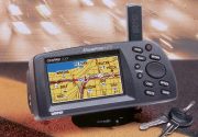
Models like this Garmin with moving map
display are good for navigating in a vehicle.
|
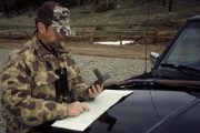
Anglers and hikers
will enjoy a handheld GPS like this Magellan model. |
In the spring of 2000, Selective
Availability, a feature that degraded accuracy of GPS for non-military
use was eliminated. What this means is that coordinates now are accurate
within 15 meters, or about 50 feet.
Current models also acquire positions
quickly. Units other than the least expensive use 12 channels, a
separate channel for each satellite that may be usable at any time.
Software is also faster, allowing a GPS new out of the box to initialize
in only two or three minutes.
What does all this mean to anglers,
backpackers, and backcountry adventurers? Confidence. Regardless of time
of day or weather, a person can know their location. Planning a trip to
unfamiliar country is also made easier. All but the least expensive
models will interface with map software on a PC, usually through a
serial port. By clicking on a map point on the monitor, a position can
be uploaded and stored in the GPS. These positions will then be used to
navigate to a remote fishing hole or camp site.
Anyone who travels in the Rockies knows
how quickly the weather can change. A storm can bring clouds, rain, and
fog, obscuring landmarks. Since a GPS works in any weather, a hiker can
find the way back to the trailhead, even in dense fog.
 |
 |
|
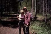
Units that use 12 channels work well even in heavy forest
areas. |
Before heading to that remote fishing hole,
save the location where you parked your truck. Your GPS will get
you back to the parking spot regardless of how far you may have
wandered from the trail. |
With the growing popularity of GPS map
makers are producing GPS-ready charts. Anyone who tried using satellite
navigation with USGS topos and other maps will appreciate the ease of
using map software. National Geographic/TOPO! and others offer
topographic maps on CD for PCs.
Once a route is planned and waypoints
stored in the GPS, the software will print a map of the area, including
a grid to make it simple to pinpoint a location. Most GPS units give the
user a choice of grids, among them Lat/Lon and UTM. Lat/Lon is the
oldest system and also the most complicated to plot due to its irregular
grid. It does have the advantage of providing a quick approximate
location. For navigation on foot, it's more complex than necessary.
Consisting of 1,000-meter rectangles, the
UTM grid is probably the simplest system. A GPS will give a pair of
numbers that make it easy to plot a map position. The pair tells the
starting point - which is always the lower left corner of a rectangle.
The last three digits of each pair are the number of meters from the
lower left corner to the right, then up, in that rectangle. Even on a
1:24,000 USGS quad, the grid size is small enough that the coordinates
can be estimated with reasonable accuracy.
All of this high-tech satellite gear
surely has a down-side. That's true. A GPS depends on battery power. In
the energy saving mode, some units will give 20 or more hours of
operation. It's wise to carry extra batteries, and a map and compass.
Other than this, there's no disadvantage in using GPS for backcountry
travel. It's the surest way to know where you are at any time in any
weather.
Copyright � 2000 by Al
Marlowe. No reproduction, linking, or copying without permission
Resources/Other Info:
|