Belle Fourche River
The Belle Fourche begins in the plains of
Wyoming, but quickly enters some very interesting and historical country.
It runs northeast, through Devil's Tower and the edge of the Black Hills.
Be sure to pick up a current Wyoming fishing regulations book, or check
locally for regs.
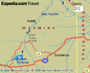
We have listed 3 access points for you
here. Each are identified by number on the map
at the bottom of this page.
You can find stream flow information on our
reports page
Key:
- Fish: Bull,
Cat, SmB, Sun for Black Bullhead,
Channel Catfish, Smallmouth Bass, and Sunfish
- Facilities: T, Camp
for Toilets, Camping
- Number (1)
corresponds to location on map
|
Below Keyhole Reservoir
(1)
- Go east from Moorcroft on I-90. Turn north at
exit 165. More info at the Keyhole
State Park website.
- Fish: Bull,
Cat, SmB, Sun
- Facilities: Camp, T
|
Devil's Tower (2)
- Access to river in Devil's Tower National
Monument. Turn off I-90 near Sundance at exit 185. Travel
northwest on US Hwy 14, and then north on Hwy 24. Devils
Tower Nat'l Monument info
- Fish: Bull,
Cat, Sun
- Facilities: Camp, T
|
 |
Colony (3)
- Take US Hwy 212 to Colony; go southwest to
river and state lease
- Fish: Bull,
Cat, Sun
- Facilities: none
|
|