Shoshone River
The Shoshone River offers a chance to land
several subspecies of cutthroats. This river starts in the Absaroka Range,
traveling east to merge with the Big Horn east of Lovell. Be sure to pick
up a current Wyoming fishing regulations book, or check locally for regs.
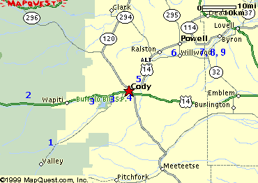
We have listed 6 access areas for you
here. All are identified by number on the map
at the bottom of this page.
You can find stream flow information on our
reports page.
Key:
- Fish: B,
Br, R, C for Browns,
Brookies, Rainbows, Cutthroats
- Facilities: T, Camp
for Toilets, Camping
- Number (1)
corresponds to location on map
|
South Fork (1)
- Go southwest from Cody on Hwy
291; travel about 29 miles; access next to highway in Shoshone
Nat'l Forest; watch out for private land!
- Some access before USFS - look
for signs
- Fish:
B, Br, C
- Facilities: Camp
-
Info
on fishing from Shoshone NF
|
North Fork (2)
|
Buffalo Bill Reservoir (3)
- Go west from Cody on US16 for about 6 miles;
access to river both above reservoir and below the dam
- Fish: B,
C, R
- Facilities: T, Camp
-
Click
here for the website on Buffalo Bill Reservoir
|
Cody - Shoshone
River Pathway (4)
- In Cody, access from River View Drive
- Fish: B,
C, R
- Facilities:
-
Click
here for the website on the Shoshone River Pathway
|
North of Cody (5)
- Go north
from Cody on US Alt14; access next to highway
- Fish: B,
C, R
- Facilities: Camp, T
|
Willwood (6)
- Go south
from Powell on Hwy 295; access near bridge across river
- Fish: B,
C, R
- Facilities: None
|
Walk-In Access (7)
- Go south
from Powell to Wildwood; go east on Road Thirteen for about 4
miles; turn north on Road Five and go about 2 miles to where
road turns east and becomes Lane Eleven. Access on south shore
of river; should be signed by WG&F. Detail map can be found
by clicking
here
- Fish: B,
C, R
- Facilities: None
|
Walk-In Access (8)
- Go south
from Powell to Wildwood; go east on Road Thirteen for about 4
miles; turn north on Road Five and go about 2 miles to where
road turns east and becomes Lane Eleven. Go east to where road
turns north as Road Three. Access on south shore of river;
should be signed by WG&F. Detail map can be found by
clicking
here
- Fish: B,
C, R
- Facilities: None
|
Walk-In Access (9)
- Go south
from Powell to Wildwood; go east on Road Thirteen for about 4
miles; turn north on Road Five and go about 2 miles to where
road turns east and becomes Lane Eleven. Continue travelling on
roads north and east to Road 10 1/2. Access on south shore of
river; should be signed by WG&F. Detail map can be found by clicking
here
- Fish: B,
C, R
- Facilities: None
|
|