Yellowstone River
The Yellowstone River starts near the SE
corner of the park, flowing for over 10 miles before entering Yellowstone
Lake. Remote fishing is offered in this area, and an opportunity to catch
(and release) Yellowstone Cutthroats. After the river leaves the lake, it
moves through a variety of settings, including mudpots and canyons. Some
vigorous hiking is required for much of the access. Be prepared for
backcountry conditions.
Yellowstone Park requires its own license,
not a WY license. Check with the park for regs - see
their website on fishing.
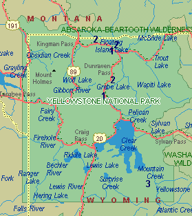
See the map at
the bottom of this page for locations
Check out river reports and stream
flows on the Reports Page
Buy
a topo map for Yellowstone Park, buy digital
maps on CD, or purchase a book
Key:
- Fish: B,
Br, R, C for Browns, Brookies,
Rainbows, Cutthroats
- Facilities: T, Camp
for Toilets, Camping
- Number (1)
corresponds to location on map
|
Downstream from
Yellowstone Lake - Road access (1)
- Access off of Grand Loop Road
between Lake and Grand Canyon (much of this is closed to
fishing); access of Grand Loop Road and Northeast Entrance Road
near Tower Junction
- Fish:
R, B, Br, C
- Facilities: Camp
|
Downstream from
Yellowstone Lake - Trail access (2)
- Trail access into Grand Canyon
(parts closed to fishing); into Black Canyon on Yellowstone
Creek or Blacktail trails; or at Garnet Hill
- Fish:
R, B, Br, C
- Facilities: Camp
|
Upstream from Yellowstone
Lake (3)
- Access by trail only - The
Thorofare trail follows much of the river upstream in the park.
A long hike - watch for bears
- Fish: B,
C
- Facilities: Camp
|
|